Grim El Niño threshold reached for the first time in 10 years

Updated . First published at
Australia is facing a greater risk of drought and bushfires for the rest of the year as the country faces its biggest El Niño event in a decade.
The Bureau of Meteorology (BOM) declared Australia was going through El Niño in June, after waters in the Pacific Ocean continued to warm.
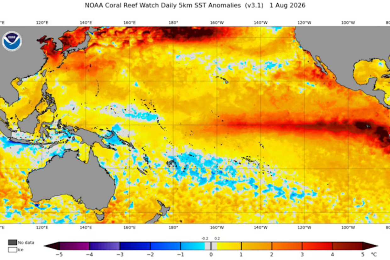
Sea surface temperatures in the Pacific Ocean are far higher than the average. Weatherzone
While the impacts of El Niño are different in each part of the world, in Australia it increases the chance of less rain and higher daytime temperatures. It also boosts the chances of droughts and bushfires.
“The latest seasonal outlooks from the BOM predict below average rain over most of the eastern half of Australia during the August-to-October period. Temperatures are also predicted to be higher than normal across most of the country during this period,” Weatherzone’s Ben Domensino said.
This year’s El Niño is also more serious than in previous years.
The strength of an El Niño event is measured by sea surface temperature anomalies, essentially how much warmer the top layer of the Pacific Ocean is compared to the long-term average. This is called the Nino 3.4 index.

Extreme El Niño conditions can lead to a greater risk of bushfires in Australia. Department of Fire and Emergency Services
Read more

Sydney nurse Claire is facing a $250,000 special levy for a balcony extension she doesn’t want
A “very strong” El Niño event occurs when sea temperatures are two degrees warmer than average; the BOM said in the week ending August 2, the index reached +2.02 degrees, exceeding two degrees for the first time since February 2016.
Domensino said current modelling predicted the phenomenon would only get stronger in the coming months, but admitted it was hard to forecast the exact implications this would have on Australia.
“Past El Niño events have shown that the strength of El Niño does not necessarily determine the strength of its impacts. However, there is no precedent to which we can compare an El Niño of this magnitude,” he said.
“We will be wading into uncharted climate territory later this year.”
“Given its current and projected strength, it will likely persist into early 2027.”
Domensino said the current El Nino event could peak at +3.5 degrees on the Nino 3.4 index in November, which would easily beat the previously monthly record of +2.65 degrees reached in November 1902.

Share a tip-off, video or photo with us


